Uhhoh!
  • Communities
  • Create Post
  • Create Community
  • heart
    Support Lemmy
  • search
    Search
  • Login
  • Sign Up
The Picard Maneuver@piefed.world to Just Post@lemmy.worldEnglish · 2 months ago

And then just going about your day

media.piefed.world

message-square
126
link
fedilink
520

And then just going about your day

media.piefed.world

The Picard Maneuver@piefed.world to Just Post@lemmy.worldEnglish · 2 months ago
message-square
126
link
fedilink
  • Hadriscus@jlai.lu
    link
    fedilink
    arrow-up
    8
    ·
    2 months ago

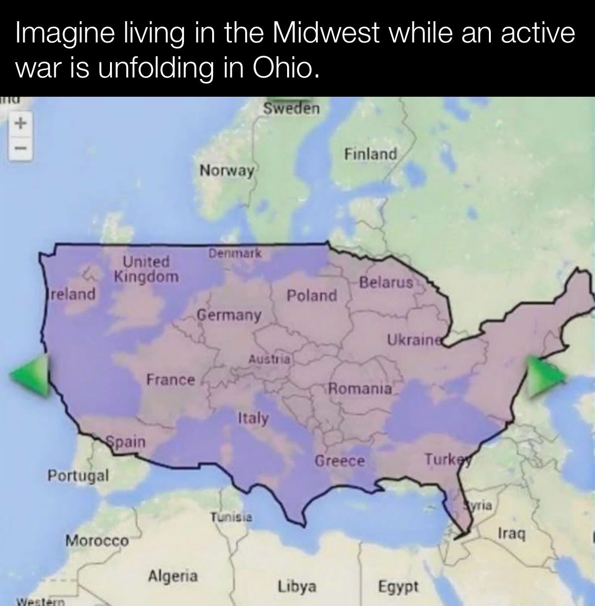
    is this an accurate representation of the US landmass ? I was under the impression they were much biger than that…, but they’re roughly the size of Europe ?

    • GreenBeanMachine@lemmy.world
      link
      fedilink
      arrow-up
      13
      ·
      2 months ago

      The whole continent of Europe is slightly bigger than the USA. The EU (union) is smaller than the USA.

    • mrmule@sh.itjust.works
      link
      fedilink
      arrow-up
      7
      ·
      2 months ago

      Yes it is https://thetruesize.com/

      • cally [he/they]@pawb.social
        link
        fedilink
        English
        arrow-up
        9
        ·
        2 months ago

        Screenshot of a map of the continental United States on top of a map of Europe, accounting for the map projection. The US stretches from just west of Ireland all the way to Türkiye and interior parts of Russia.

        It looks just slightly bigger than in the OP’s screenshot

        • mrmule@sh.itjust.works
          link
          fedilink
          arrow-up
          1
          ·
          2 months ago

          If you move it the coast of Ireland (like the original) I’d say it’s pretty much the same

        • wavebeam@lemmy.world
          link
          fedilink
          arrow-up
          2
          arrow-down
          2
          ·
          2 months ago

          The entirety of Oregon and most of California and Washington are ocean in this image

          • 🌞 Alexander Daychilde 🌞@lemmy.world
            link
            fedilink
            English
            arrow-up
            1
            ·
            2 months ago

            deleted by creator

        • Atomic@sh.itjust.works
          link
          fedilink
          arrow-up
          1
          arrow-down
          2
          ·
          2 months ago

          The two “maps” are wildly out of proportions anyway. Looks like Sweden is the size of the entire US West Coast. When in reality it’s about the size of California

          • Captain Aggravated@sh.itjust.works
            link
            fedilink
            English
            arrow-up
            2
            ·
            2 months ago

            Given how the US border is distorted (Maine is north of the 49th parallel) I’m guessing this is one of those maps that distorts things as you move them around to keep the area constant. Like look how big Greenland looks up in the corner.

            • Atomic@sh.itjust.works
              link
              fedilink
              arrow-up
              1
              ·
              2 months ago

              Greenland is not in the image

              • Captain Aggravated@sh.itjust.works
                link
                fedilink
                English
                arrow-up
                2
                ·
                2 months ago

                Then what is the unlabeled landmass at the very top left, northeast of Iceland?

                • Atomic@sh.itjust.works
                  link
                  fedilink
                  arrow-up
                  2
                  ·
                  2 months ago

                  The landmass in the very top left on the image in this post. Is Iceland.

                  Greenland is not northeast of Iceland either. It’s northwest.

                  • Captain Aggravated@sh.itjust.works
                    link
                    fedilink
                    English
                    arrow-up
                    1
                    ·
                    2 months ago

                    I meant this one, from earlier in this thread.

          • mrmule@sh.itjust.works
            link
            fedilink
            arrow-up
            2
            ·
            2 months ago

            One of the most common criticisms of the Mercator map is that it exaggerates the size of countries nearer the poles, while downplaying the size of those near the equator

            For example, let’s move Russia towards the equator

            • Atomic@sh.itjust.works
              link
              fedilink
              arrow-up
              1
              ·
              2 months ago

              Mercator does compensate for that by introducing reference rectangles. But of course, that doesn’t help when people making posts using those maps, are unaware of how to read them. And also just remove said reference rectangles

    • Captain Aggravated@sh.itjust.works
      link
      fedilink
      English
      arrow-up
      5
      ·
      2 months ago

      Alaska and Hawaii aren’t pictured.

      • 🌞 Alexander Daychilde 🌞@lemmy.world
        link
        fedilink
        English
        arrow-up
        2
        ·
        2 months ago

        Because they’d be in Morocco![1]


        1. As any good US elementary school map of the US would show! ↩︎

    • azuth@sh.itjust.works
      link
      fedilink
      English
      arrow-up
      4
      ·
      2 months ago

      The USA is slightly smaller than Europe (not the EU) if you include Alaska and Hawaii

Just Post@lemmy.world

justpost@lemmy.world

Subscribe from Remote Instance

Create a post
You are not logged in. However you can subscribe from another Fediverse account, for example Lemmy or Mastodon. To do this, paste the following into the search field of your instance: !justpost@lemmy.world

Just post something 💛

Lemmy’s general purpose discussion community with no specific topic.

Sitewide lemmy.world rules apply here.

Additionally, this is a no AI content community. We are here for human interaction, not AI slop! Posts or comments flagged as AI generated will be removed.

Visibility: Public
globe

This community can be federated to other instances and be posted/commented in by their users.

  • 57 users / day
  • 410 users / week
  • 2.02K users / month
  • 7.02K users / 6 months
  • 1 local subscriber
  • 1.46K subscribers
  • 378 Posts
  • 4.53K Comments
  • Modlog
  • mods:
  • suns3t@lemmy.world
  • dual_sport_dork 🐧🗡️@lemmy.world
  • BE: 0.19.17
  • Modlog
  • Instances
  • Docs
  • Code
  • join-lemmy.org